Trailblazing Houston Bike Rides

The Houston Bike Trail System: "It's like you took a bag of Cheetos and spilled it on a picnic table.” (Houston Chronicle) A better analogy might be fetal neuronal dendrites trying to connect up into a living viable neuronal network. Until a plan to connect up the existing trails into a network is further along, we have to grow our own dendrites between the Cheetos. Houston has some quite remarkable bikeways like the Buffalo Bayou Trail, Braes Bayou Trail, Heights Trail, and the White Oak Bayou Trail. The problem is to get to them and between them. This blog will try to connect these bike trails to each other to make for charismatic bike rides through Houston.

Bike riders in Houston are a bit like armadillos, trying not to become road kill. The challenge in trailblazing bikeable rides in and about Houston is to find, between the official bikeways, connecting links that are quite untrafficked by cars. This means, when possible, avoiding thoroughfares like Chimney Rock, Buffalo Speedway, Memorial, or Kirby, the obvious straight routes through town, dominated by we, the motorists. Instead, we must cut trails using residential streets, streets which seem pretty much designed to discourage motorist use. The best streets have little traffic, cars parked on the street in front of houses, children playing on the front lawn, or on the street. Sometimes however, we can't avoid the major thoroughfares, so that means riding on the sidewalks. Luckily, there are rarely pedestrians on sidewalks, so it is quite feasible. The problem is that the cars, which don't expect pedestrians, will pull out into the sidewalk right in front of you. Be aware.

Generally, I have only tested these bike rides on weekends, when traffic is particularly favorable. Also, I take a
Grant Peterson Rivendell Unracer approach, what might be called "bikehiking". Houston is a different world when seen from an easy rider point of view. And you don't need to be dressed in racer drag to appreciate your own backyard. You rode a bike as a kid. If you are just getting back into it, I highly recommend Grant Peterson's book Just Ride. It may help you not to get the latest, fastest, uncomfortable bike that's unrideable on the potholed streets of Houston, i.e., the one recommended by your bike shop's racing enthusiast.

Houston could be a great biking city - which might help it to become a great city. The bayous, ditches, power line easements and disused railway easements interweave through the city as a hidden and unused biking internet. What will bring this network to life? I wonder.

Notice the List to the right called "1. Bike Rides Around Houston". Start with the Primary Houston Bike Loop to orient yourself.

Nothing is real. Discipline your mind to enjoy the ride...


Friday, October 5, 2012

Primary Houston Bike Loop

Primary Houston Bike Loop
View Map at MapMyRide. MapmyRide has an iPhone app that lets you download maps to consult on the ride.  

Learn this loop to access all the trails discussed here.

I call this the Primary Houston Bike Loop because it can be used as a way to bike to interesting Bike Trails in Houston including the Memorial Park, Buffalo Bayou Park Trails, and the Brays Bayou Trail. In future posts, I will show how you can access the Tap Rail Trail, the Heights Trail, and the beautiful White Oaks Trail from off the Primary Houston Bike Loop.


Braes Bayou
Brays Bayou


The Loop shows Houston off quite well except for a short portion through a light industrial area near Bellaire. But these areas are where the work is done so they have their interest. The Loop passes through Rice University, the University area, Bellaire, near the Galleria, through Tanglewilde, Memorial Park, and Montrose.

Memorial Park Trail


Memorial Park Trail


West side of loop... the tricky part.

The trickier part of the ride is the West side of the loop. The reason is that I had to be a trailblazer. The official bike routes don't work for me here because of their ugliness and they are straight-shot highly trafficked roads. So here is a neighborhood route sans traffic.
West side of Loop
West side of Loop

.


Leave the Brays Bayou Trail At Moonlight.


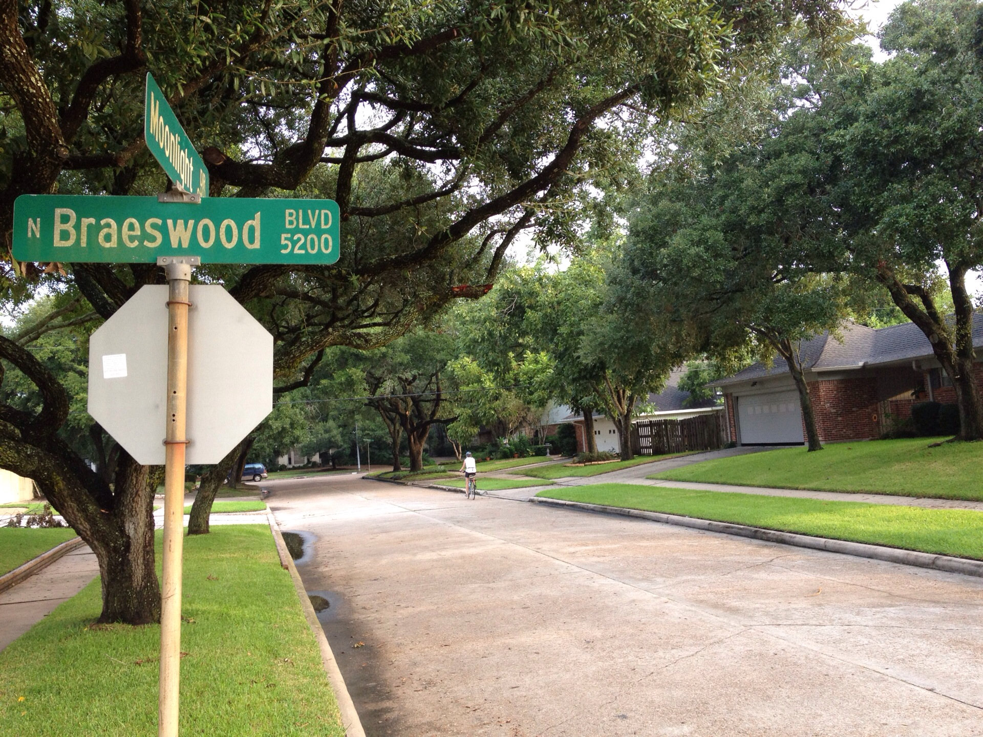
Moonlight to Braesvalley. Right on Braesvalley.

 
Left on Manhattan.
 
Right on Jason.
 
Immediate left on Ferris.
.
Keep on Ferris past Beechnut.
 
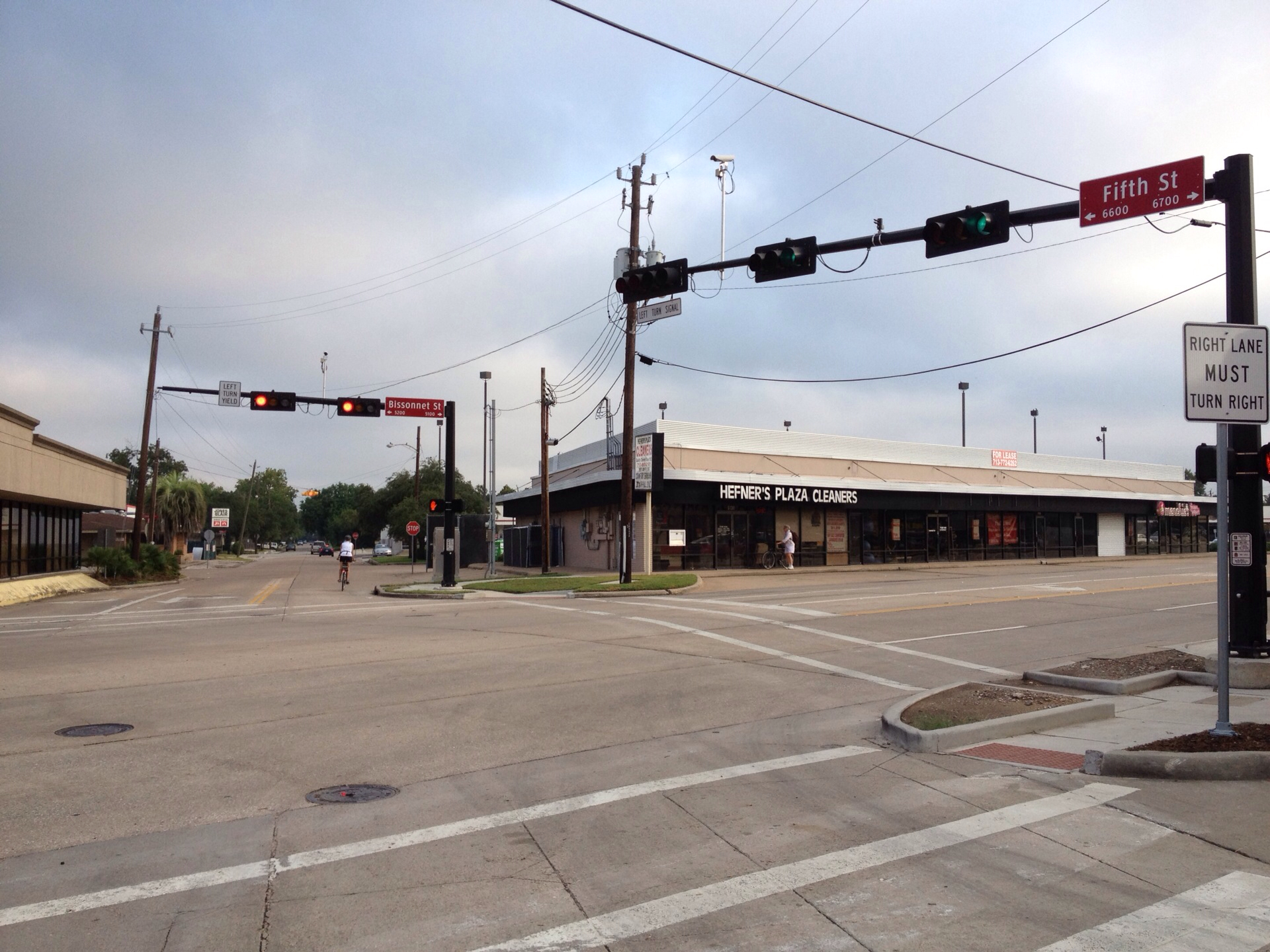
Ferris past Beechnut and Bellaire High school to Jessamine. Right on Jessamine.
 
Left on Fifth.
 
Cross Bellaire.
 
Go straight and Cross little parking lot and then cross Bissonnet.
 
Take Fifth to Elm. Left on Elm.

 
Right on Royalton through the Wasteland.
 
Right at Westpark. Ride on the concrete under the Westpark Tollway to avoid Westpark traffic.
 
Left on Rice crossing Westpark.
 
Veer left off Sage staying on Rice.
 
Turn off Rice left onto Beverly Hill.
 
Turn right onto Yorktown.
 
Cross Richmond onto sidewalk and go left.
 
Yorktown picks up half a block west on Richmond. Right onto Yorktown.
 
Follow Yorktown to gate. You can now follow the bike route signs and the MapMyRide Map to Memorial Park trail to continue around the Loop.

When you reach Woodway stay on the sidewalk. It will turn into a bikeway.

Where to eat on the Loop.

Ziggy's at the corner of Taft and Fairview is pretty organic, at least their eggs are. Hard to find organic food near the loop.
 
Ziggys caters to bikers. Here is an embellished soy latte.


Also Baba Yega's is close to the loop and they have good breakfasts and lunches. They are a couple blocks south of Fairview and one block east of Montrose.


Have fun on the Loop. Leave a comment if you have a suggestion. Nothing is real. Enjoy the ride.


Heights Trail from Primary Bike Loop

See map on MapMyRide. Always start with the Primary Houston Bike Loop to get oriented and to get access to trails. MapMyRide has an iPhone app that lets you download maps to consult on the ride.

This route connects you to the Heights Trail from the Primary Loop on the Buffalo Bayou Trail near Taft. Use the Primary Loop to get you to the start location at Taft.

The only real challenge on this ride is to cross Memorial. There is a foot bridge accessible from Sabine, and you can carry your bike crossing the bridge.

Foot Bridge across Memorial at SabineFoot Bridge at Sabine & Memorial
 
One place to repast along the way or to get some java is the Java Java Cafe. Can't really recommend the place but YMMV. It is located a couple of blocks to the west of the Heights Trail on 11th. There is a place for your bike on the west side of the building. Look for the old creaky gate.

This ride is not a loop so when you reach the end near 610 North, turn around to return to the Primary Bike Loop.


White Oak Trail via Heights Trail from Primary Loop

View route at MapMyRide. Always start with the Primary Houston Bike Loop to get oriented and to get access to trails. MapMyRide has an iPhone app that lets you download maps to consult on the ride.

This route starts on the Primary Loop, crosses Memorial via the bridge at Sabine, continues on the Heights Trail, and then connects via neighborhood streets to the White Oak Trail.

This is a beautiful spanking new trail that takes you far enough up the White Oak Bayou that you get beyond the sad cementing of the Bayou that was done in the 50's and 60's. Beyond the cement, the bayou seems more like a stream.

If you do the Primary Loop and to the end of the White Oak Bayou Trail and back, you have ridden almost 50 miles, give or take.


Thursday, October 4, 2012

Brays Bayou East via Primary Loop

See map on MapMyRide. Always start with the Primary Houston Bike Loop to get oriented and to get access to trails. MapMyRide has an iPhone app that lets you download maps to consult on the ride.

This ride starts anywhere on the Brays Bayou Trail and heads east. You can access the Brays Bayou Trail from the Primary Loop.


A lot of work is going into the beautification of eastern part of Brays Bayou Trail near the Medical Center. Really worth checking out. From the trail you can access Hermann Park and the Medical Center as well as the Columbia Tap Trail.


More on Project Brays.